Permian Basin Geology: The 250-Million-Year-Old Treasure Beneath Landman
Two sub-basins, stacked pay zones, and 46 billion barrels — why the geology under West Texas drives every scene in the show
West Texas setting guide
How this topic fits the world of Landman
This article explains one part of the larger West Texas story behind the series. For the full map of setting, filming reality, Midland-Odessa, and the Permian Basin, start with the West Texas in Landman hub.
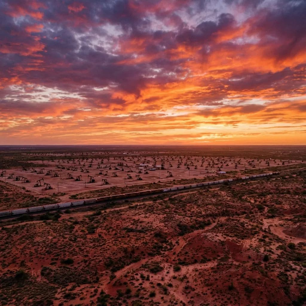
Open the West Texas hubWhen viewers of Taylor Sheridan's hit series Landman look across the screen, they see endless expanses of flat, dusty West Texas scrubland. But the true star of the show isn't the landscape above the ground; it's the astonishing geological fortress buried two miles beneath it. The relentless conflict, the staggering multi-million dollar lease agreements, and the high-speed race to drill are all driven by one of the most prolific oil-producing regions on Earth: The Permian Basin.
To understand the ferocious economy of West Texas and the high-stakes world of Tommy Norris, you must understand the dirt. Here is the definitive breakdown of the Permian Basin's geology — including the 2024 productivity data that reveals the Basin's greatest emerging challenge.
What is the Permian Basin? A 75,000-Square-Mile Ancient Ocean
Geologically speaking, a "basin" is a massive depression in the Earth's crust. The Permian Basin stretches approximately 250 miles wide and 300 miles long across West Texas and southeastern New Mexico, encompassing roughly 75,000 square miles — larger than the entire state of Florida.
During the Permian geologic period (roughly 299 to 252 million years ago), this area wasn't a sun-baked desert; it was a vibrant, shallow inland ocean known as the Permian Sea. Over millions of years, countless trillions of marine organisms, algae, and prehistoric sea life lived and died in this ocean, sinking to the basin floor. As tectonic plates shifted and the ocean dried up, these organic remains were buried beneath thousands of feet of sediment, salt, and rock. Intense subterranean heat and crushing pressure slowly cooked this organic matter over geological timescales, transforming it into the rich hydrocarbon deposits we call crude oil and natural gas.
🌍 The Global Scale (2024-2025)
5.5+ Million Barrels Per Day
The Permian Basin is not just America's largest oil field; it is the single largest producing oil region on the planet — having recently surpassed Saudi Arabia's Ghawar field. If the Permian Basin were a country, it would be the world's third-largest oil producer, behind only the rest of the United States and Saudi Arabia. It also accounts for 23% of total U.S. natural gas production, with much of that as "associated gas" produced alongside oil. Sources: EIA, World Oil
The "Layer Cake": Delaware vs. Midland Sub-Basins
The Permian Basin isn't one giant hollow bowl. It is structurally divided by a massive submerged mountain range called the Central Basin Platform. This divides the region into two primary powerhouse sub-basins, each with distinct geological characteristics that create fundamentally different drilling economics:
The Midland Basin (The Traditional Giant)
Located on the eastern side (beneath the cities of Midland and Odessa), this sub-basin is famous for its relatively consistent geology. The Wolfcamp formation here is 400-1,600 feet thick, with predictable stratigraphy that allows operators to standardize their drilling programs into an "assembly line" approach. This is the historic heartland of Texas wildcatters and the setting of Landman.
The USGS assessed the Midland Basin's Wolfcamp and Spraberry formations at 20 billion barrels of technically recoverable oil, 16 Tcf of gas, and 1.6 billion barrels of NGLs. Break-even prices average $61/barrel in 2025.
The Delaware Basin (The Deep Frontier)
Located to the west and extending into New Mexico, the Delaware Basin is deeper, more geologically complex, and contains dramatically thicker sequences of productive rock — the Wolfcamp here averages 10,000-12,000 feet deep and can exceed 6,000 feet in total thickness. For decades, it was considered too difficult and expensive to exploit.
The USGS's 2018 assessment changed everything: the Delaware Basin's Wolfcamp and Bone Spring formations contain an estimated 46.3 billion barrels of oil, 281 Tcf of gas, and 20 billion barrels of NGLs — more than double the Midland Basin's assessed resources. Break-even prices average $62/barrel in 2025.
📊 Delaware vs. Midland: The Numbers
| Metric | Midland Basin | Delaware Basin |
| Recoverable Oil (USGS) | 20 billion bbl | 46.3 billion bbl |
| Natural Gas | 16 Tcf | 281 Tcf |
| Wolfcamp Thickness | 400-1,600 ft | Up to 6,000+ ft |
| Wolfcamp Depth | ~7,000-8,000 ft | 10,000-12,000 ft |
| 2025 Break-even | $61/bbl | $62/bbl |
| Key Formations | Wolfcamp, Spraberry, Dean | Wolfcamp, Bone Spring, Avalon |
The Wolfcamp Shale: The Crown Jewel
You cannot discuss the Permian Basin without discussing the Wolfcamp formation. The Permian is a "stacked play" — instead of one reservoir, it has dozens of oil-bearing zones layered on top of one another like a geological wedding cake (Spraberry, Bone Spring, Wolfcamp, Avalon, Dean).
The Wolfcamp shale, which horizontally spans almost the entire basin, is the undisputed king. It is divided into four "benches" — Wolfcamp A, B, C, and D — with the A and B benches being the most frequently targeted for drilling due to their superior reservoir quality. Porosity typically ranges from 2% to 12%, averaging about 6%.
The combined Wolfcamp-Bone Spring assessment of 46.3 billion barrels in the Delaware Basin alone represents the largest continuous oil assessment ever conducted in the United States. To put this in perspective: at current prices, the oil beneath the Delaware Basin is worth roughly $3 trillion.
🛠️ Why the "Wolfbone" Changed Everything
In the Delaware Basin, the Wolfcamp and Bone Spring are so intertwined that the industry coined the term "Wolfbone" to describe them collectively. The Bone Spring consists of interbedded sandstones, carbonates, and shales deposited as submarine fans, with total thickness reaching 4,000 feet. Combined with the Wolfcamp, this creates a vertical column of productive rock so thick that operators can drill 6-8 wells from a single surface pad, each targeting a different layer — a practice called "cube development." This geological gift is why Tommy Norris's lease negotiations are so valuable: a single ranch might sit atop four or more separate "pay zones." Sources: Enverus, EIA
The Elephant in the Room: Tier 1 Depletion (2024 Data)
For all its geological bounty, the Permian Basin faces a challenge that industry insiders discuss in hushed tones: the best acreage is running out. Analysis of 2023-2024 well data reveals a troubling trend:
- Delaware Basin: Wells drilled in 2023-2024 showed an average productivity decline of 5% per lateral foot compared to 2021-2022 wells
- Bone Spring: Experienced a 12% decline in per-well productivity over the same period
- Wolfcamp: A more modest 1% decrease, but still a reversal from years of improvement
This decline suggests that the most productive "Tier 1" acreage — the geological sweet spots with the highest porosity, best pressure, and richest organic content — is being extensively developed and depleted. As operators push into less productive Tier 2 and Tier 3 acreage, each new well produces less oil, requiring more wells (and more capital) to maintain the same production levels.
In response, operators are exploring alternative formations like the Barnett and Woodford shales that underlie the traditional targets. These deeper formations show comparable oil performance with less water production — a potential solution to both the depletion problem and the earthquake-causing wastewater injection crisis.
⚠️ The Gas-to-Oil Ratio Problem
Across the Wolfcamp, Bone Spring, and Spraberry, operators are observing rising gas-to-oil ratios (GOR). As reservoirs are depleted, wells increasingly produce more natural gas relative to oil. With gas prices significantly lower than oil prices per energy-equivalent barrel, this shift erodes well economics. The rising GOR contributed to the Permian accounting for 23% of U.S. marketed gas production in 2025 — gas that operators often didn't plan for and pipelines weren't built to handle. Source: TGS
Why Geology Creates the Drama
Why does Taylor Sheridan focus Landman on this specific piece of earth? Because geology dictates the economics, and economics dictate human behavior.
Because the Permian is a "layer cake," a single 500-acre ranch above ground could hide four or more distinct layers of oil below. This means the mineral rights are astonishingly valuable. A landman like Tommy Norris isn't just negotiating for one well; he's negotiating for the right to drill vertically down two miles, turn the drill bit 90 degrees, and drill horizontally for another three or four miles through a subterranean layer of the Wolfcamp.
The geology of the Permian Basin means that an oil company can spend $10 million on a single well, confident that the oil is there. It removes the "wildcatting" risk of the 1920s and replaces it with industrial-scale, manufacturing-style extraction. The only limit is how fast they can acquire the leases — creating the fierce, cutthroat competition that defines the series.
But the Tier 1 depletion data adds a new dimension to the drama: the best acres are finite. The race isn't just about being first anymore — it's about whether the geology you're leasing is still worth the $10 million investment. In a world where every lateral foot produces 5% less oil than it did two years ago, the margin for error is shrinking fast.
Realism Score: 9/10
Landman's geological foundation is among the most accurate elements of the show. The stacked pay concept, the fierce competition for mineral rights, and the industrial scale of Permian development are all depicted with impressive fidelity. The show loses a point only for not yet exploring the Tier 1 depletion narrative — a story that would add genuine existential tension to M-Tex's drilling economics and create compelling drama around whether the next lease is a goldmine or a money pit.
Frequently Asked Questions About Permian Basin Geology
Will the Permian Basin ever run out of oil?
The Permian won't "run out" in a dramatic sense, but its best acres are being depleted. USGS estimates over 46 billion barrels of technically recoverable oil in the Delaware Basin alone, suggesting decades of remaining production. However, 2023-2024 data shows per-well productivity declining 5-12% in key formations, indicating the most prolific Tier 1 acreage is being exhausted. The Basin will produce oil well into the late 21st century, but at diminishing rates per well unless new technology or formations are unlocked.
What is a "stacked pay" basin and why does it matter?
A stacked pay means multiple oil-bearing rock layers are stacked vertically, separated by impermeable barriers. In the Permian, a single deep wellbore can pass through 5-6+ productive zones (Spraberry, Dean, Wolfcamp A/B/C/D, Bone Spring 1st/2nd/3rd). This allows operators to drill multiple horizontal wells from one surface pad, each targeting a different layer — "cube development." It's why a single ranch's mineral rights can be worth tens of millions: there isn't one well's worth of oil underneath, there might be eight.
What is the difference between the Delaware Basin and Midland Basin?
The Midland Basin (east) has thinner, shallower, more predictable geology — ideal for standardized, "assembly line" drilling. The Delaware Basin (west, extending into New Mexico) is deeper, thicker, and more complex, but holds over double the assessed resources (46.3 billion vs. 20 billion barrels). The Delaware contains the Bone Spring formation absent from the Midland, and its combined "Wolfbone" package creates an enormous vertical column of productive rock. Both basins have similar 2025 break-even prices (~$61-62/barrel).
What are Tier 1, Tier 2, and Tier 3 acreage in the Permian?
These tiers reflect the geological quality of the rock. Tier 1 acreage has the highest porosity, best reservoir pressure, richest organic content, and produces the most oil per lateral foot — typically the highest-return wells. Tier 2 and 3 are progressively less productive. As operators exhaust Tier 1 locations, they move to Tier 2-3 acreage where well economics are tighter. The 5-12% productivity decline observed in 2023-2024 wells suggests significant Tier 1 depletion is underway, making lease quality — the very thing landmen evaluate — more critical than ever.
How does the Permian Basin compare to other major oil fields globally?
At 5.5+ million barrels per day, the Permian Basin produces more oil than any other single oil-producing region on Earth. If it were a country, it would rank as the world's third-largest oil producer. Saudi Arabia's Ghawar field, long the global production champion, has been surpassed. The Permian's dominance is built not on conventional reservoirs like Ghawar, but on tight shale rock unlocked by horizontal drilling and hydraulic fracturing — a fundamentally different geological and engineering challenge.
What is the rising gas-to-oil ratio and why does it matter?
As Permian reservoirs are produced, wells increasingly yield more natural gas relative to oil. This rising gas-to-oil ratio (GOR) matters because gas is worth significantly less per energy-equivalent barrel than oil. A well that was economically excellent producing mostly oil becomes marginal if it shifts to mostly gas. The rising GOR also creates infrastructure challenges — the Permian's pipeline and processing capacity was built for oil, and the unexpected gas volumes have caused flaring issues and required billions in new midstream investment.
Sources
- Wolfcamp-Bone Spring Assessment: 46.3 Billion Barrels - USGS (2018)
- Permian Basin Geology: Wolfcamp and Bone Spring Formations - EIA
- Wolfcamp vs. Bone Spring: Delaware and Midland Comparison - Enverus
- USGS Wolfcamp Assessment by Sub-Basin - SPE
- 2023-2024 Well Productivity Decline: 5-12% Per Lateral Foot - TGS
- Rising Gas-to-Oil Ratios Across Permian Formations - TGS
- Barnett and Woodford as Alternative Formation Targets - TGS
- 2025 Break-even Prices: Midland $61, Delaware $62 - World Oil
- Permian 23% of U.S. Marketed Gas Production (2025) - EIA
- Wolfcamp Thermal Maturity and Depositional Environment - UT Austin
- Wolfcamp Cumulative Production: 0.93 STB/ft/month Average - ResearchGate
- Pore Pressure Variations Across Permian Formations - OnePetro
- Wolfcamp, Bone Spring, Spraberry Production Drivers - Midland Reporter-Telegram
- USGS Delaware Basin Assessment Details - Lab Manager
Related Blog Reading
More Landman analysis on this topic
Half the Barrel: How One Texas Basin Became America’s Oil Engine
By any measure that matters—barrels, budgets, or geopolitical leverage—the center of U.S. oil gravity sits under a hard blue sky in West Texas and southeastern New Mexico. The Permian Basin is not just another field; it is the field. In 2024 it supplied roughly 48% of all U.S. crude, an average of 6.3 million barrels a day, according to the U.S. Energy Information Administration (EIA). That single statistic explains an outsized share of America’s energy story—why exports hit record highs, why Gu

From Desert to Boom: A Century of Rise and Fall in West Texas Oil Towns
Opening: Through the Lens of Landman The opening shots of Landman tell you everything you need to know about West Texas: an endless expanse of flat, scrubby desert stretching to the horizon, interrupted only by the rhythmic bobbing of countless pump jacks—mechanical horses drinking crude from deep beneath the earth. Dust devils swirl across two-lane highways where 18-wheelers loaded with drilling equipment roar past at dangerous speeds. Through the heat shimmer, you can see the orange glow of g

Is Landman Based on a True Story? The Boomtown Podcast and Real West Texas Oil Boom Explained
Landman is fictional, but it is rooted in the Boomtown podcast and the real Permian Basin oil boom. Here is what comes from reality, what is dramatized, and why the show feels so specific.

Roughneck Culture: Life and Faith of West Texas Oil Field Workers
In the vast, sun-scorched expanse of West Texas, under a sky that stretches into an infinite blue, a modern-day archetype toils for the black gold that fuels the world. He is the roughneck, a figure as central to the mythology of Texas as the cowboy, yet often shrouded in a layer of crude oil and misunderstanding. As Taylor Sheridan’s series Landman drills into the high-stakes world of the Permian Basin, it brings this figure to the forefront—the man on the rig floor, the engine of the boom. To